
Travel Mitta Mitta – A River Runs Through It
Words: Jeremy Bourke | Images: Don Fuchs
The range that holds Victoria’s highest mountains has been described as a giant sponge.
Forming the southern end of the Australian Alps, it absorbs the area’s high rain and snowfall and releases it slowly through countless pores to form the soaks, streams, creeks and ultimately the rivers that feed into the catchment of the continent’s largest river system, the Murray–Darling Basin.
It’s late October, a bracing –2°C and a powdering of overnight snow has dusted the range. The beams of morning sun glint on the ice crystals as we stand in the lee of Mt Hotham. Somewhere below is the elusive source of the dancing Mitta Mitta tributaries that themselves become a tributary of the mighty Murray River. Protected as a “heritage river” in its upper reaches, the Mitta Mitta plays a major role in the ecology, history and economy of this high corner of Victoria.
Along its 204 km course, it slices through terrain so rugged there’s only trace evidence of human habitation – either past or present – until it emerges into a picturesque farming valley. Modern engineering has tamed this wild force of nature into a significant provider of water for the Murray–Darling Basin, which currently serves more than 16 per cent of Australia’s population.
The Mitta Mitta’s importance is hard to appreciate, when you’re on wooded slopes remote from any permanent settlement other than a lofty ski village above.
Photographer Don Fuchs and I are seeking the start of the Mitta Mitta’s most significant tributary, the Cobungra River. Our route lies along the Australian Alps Walking Track, but the weather forces us to rely on orange snow pole markers for guidance.
As we descend, the ground becomes sludgy, then pools appear from which a stream trickles. This, we reason, must be the beginning of Swindlers Creek, one of dozens of little watercourses that feed the Cobungra.
We finally enter the treeline and pass through a copse of snow gums believed to be up to 400 years old, just before the shelter known as Derrick Hut. This eventually gives way to wattle, its yellow blooms acknowledging the spring, and we descend into Cobungra Gap to just below the Cobungra River’s official starting point. Its roaring flow can be heard well up the hill.
We could have chosen any of the Mitta Mitta’s feeder sites to begin this river’s story, but Hotham incorporates the human element. Local historian and archaeologist Andrew Swift attributes this area’s development to rivers of gold, not water.
“Its geology is basically sedimentary rocks overlaid with basalt, and gold deposits from ancient river streams eroded into it over time”, he says.
Andrew has extensively researched the area’s diggings, particularly at Brandy Creek, found via a track off the road between Mt Hotham and the village of Dinner Plain. The track traverses the course of a 12 km water race from the head of Swindlers Creek, which fed the hydraulic sluicing machinery used to dislodge the alluvial gold. The flow-on effect of being able to harness this river’s power, he says, led to the opening of the Great Alpine Road, which in turn opened up the High Country to recreational visitors.
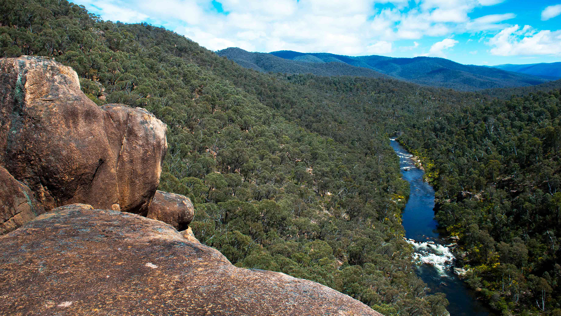
As the Mitta Mitta flows south, it incorporates a series of rapids with evocative names such as Graveyard, Dislocation and Bump & Grind. It’s a whitewater rafter’s paradise.
The Great Alpine Road shadows the Cobungra for about 35 km, and provides only a few access points to the river. One is a deep descent below Victoria Falls to the site of an abandoned power station. This attempt to harness the river’s power to run the Cassilis Gold Mine lasted just nine years until the mine closed in 1916. Debris on the bank at least 5 m above the current water level shows how high this wild river can run.
From here, the Cobungra turns north, well away from the Great Alpine Road, and isn’t sighted again until it meets the Big River, near Anglers Rest. This confluence of two significant streams – the Cobungra from the west and the Big from the north, abetted by the arrival of the Bundara River a few kilometres upstream – is regarded by the Murray–Darling Basin Authority as the starting point of the Mitta Mitta, because this is the place where the river flow turns around and heads towards the Murray.
Linton Smith, who’s been paddling here for 40 years and runs whitewater excursions through the gorge carved by the Mitta Mitta, describes the river as “wicked”.
“When I first paddled this, I spent five years looking at rapids before I actually took a look at the scenery, which is stunning,” he says. “It’s incredible that pristine wilderness is smack in the middle of Victoria. People don’t perceive wilderness as being Victorian at all, and they get here and think they’re in New Zealand or Tasmania. That’s the experience the river has”.
The Mitta Mitta, Linton says, must be respected.
“When there’s a lot of snow in the catchment and warm rain falls on it, it all comes down at once and that’s when the river is at its most dangerous and you don’t want to be out there. All the rapids link together.
“We’ve run it in moderate flood conditions. This section [the gorge] usually takes 4–5 hours to paddle, and [that day], it took 47 minutes from start to finish!”
This side of Dartmouth Dam, the Mitta Mitta is so remote it hosts no town or even village. Anglers Rest, a few kilometres up the Cobungra, is the only populated community. And the only thing there is the Blue Duck Inn, with a fame that easily outweighs its size. “Everyone knows the Blue Duck Inn”, says Michael Mullins, who, with partner Lana Anthony, has owned the 90-year-old hotel since 2009. “We get people from overseas ring up. There’s a lot of camping in the area”. The area is also a beacon for trout fishers, canoeists and motorcyclists.
For trout (the most popular river fish for anglers in Victoria), Michael’s favourite spot is in front of his hotel. “I think the Cobungra is fished the least,” he says. “Blackberries make it pretty inaccessible in a lot of areas.” The narrow flat across the river from the inn had significance long before its present-day use as a camping ground. It’s one of several sites along the Mitta Mitta and its tributaries identified as stopping places for the major First Nations people from this area, the Ya-itma-thang, who believed the river to be a source of a special force. According to anthropologist Aldo Massola in his book Journey to Aboriginal Victoria (published in 1969), the Ya-itma-thang people would collect quartz crystals known as gibba from the water. These possessed magical powers and, invisibly projected by the medicine man, would kill an enemy.
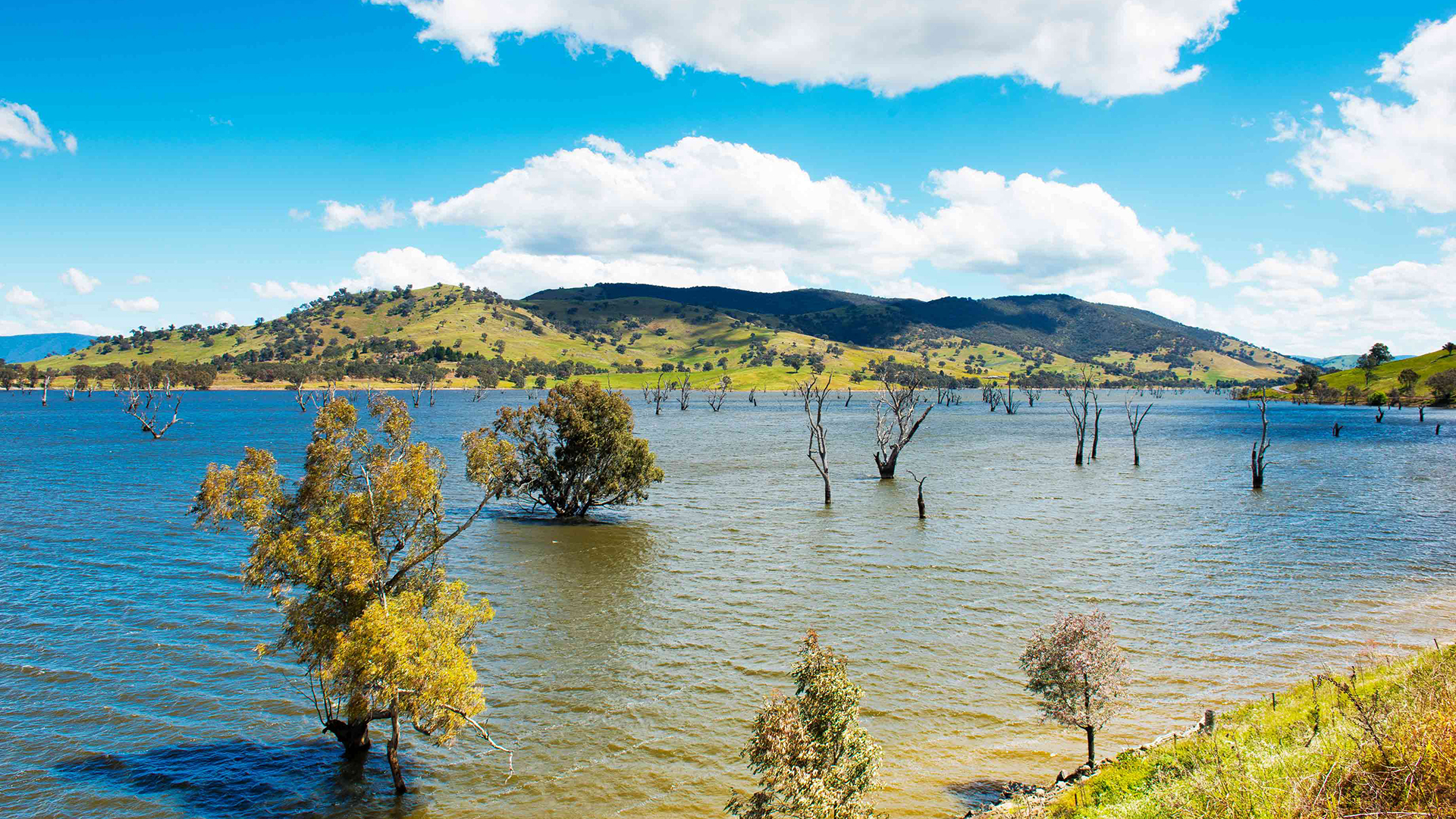
After the gorge, the Mitta Mitta escapes the mountains, flowing into a valley described in 1835 by early pastoralist George Mackillop as “60,000 acres of as fine land as I have seen in the Colonies”. By early 1836, cattle had been brought to the area and, today, the Mitta Mitta Valley has some of the finest beef and dairy pasture in the state.
There are no communities of any note serving these industries until after the Mitta Mitta passes through Lake Dartmouth. The largest is Eskdale, 50km from where the river meets Lake Hume, but it’s preceded by Mitta Mitta, a respite for those who have completed the countless tight bends on the Omeo Highway from Anglers Rest.
Before Eskdale is Dartmouth, a place that didn’t exist until John Scales’ grandfather was obliged to hive off 130 ha of the property Banimboola in 1971 as the site to house workers on the Dartmouth Dam project, constructed to store water for irrigation, stock and domestic use.
“We weren’t really keen on losing [that land] because it was all river frontage country and the best of what Banimboola had to offer,” says John, a fifth-generation farmer here. “The whole regime of the river has turned upside down since Dartmouth Dam was built,” he says. “You now get your high flows in the summer because it’s irrigation flow, and for a large amount of the time the Mitta runs at thousands of megalitres [a day] – the equivalent of 4000 Olympic-sized swimming pools of water.
“Then in the winter, when the big flows are coming in, they’re storing water so you only get a 200 ml flow [80 pools]”. And that, John adds, is not the river’s finest hour, despite his assertion that the dam has been good for the valley overall. “I’ve seen the Mitta go from a vibrant, dependable, really exciting river that would run up to 50,000 ml at times, to just a drain. At a 200 ml riparian flow, the river this side of Mitta Mitta [township] is a bit of an embarrassment.”
But at the other end of the scale, overflows have been spectacular. “Every time it’s flowed over it’s boosted the economy of Dartmouth no end”, John recalls. “It’s happened on about five occasions. The last time it occurred, in November 1996, 23,500 ml came over the spillway. There were unprecedented rains, warm rain on snow from the alpine country and the dam was rising a metre a day.
“It was the most magnificent sight you’d see anywhere in Australia. There was a line of cars from Albury to Dartmouth that you couldn’t break into”.
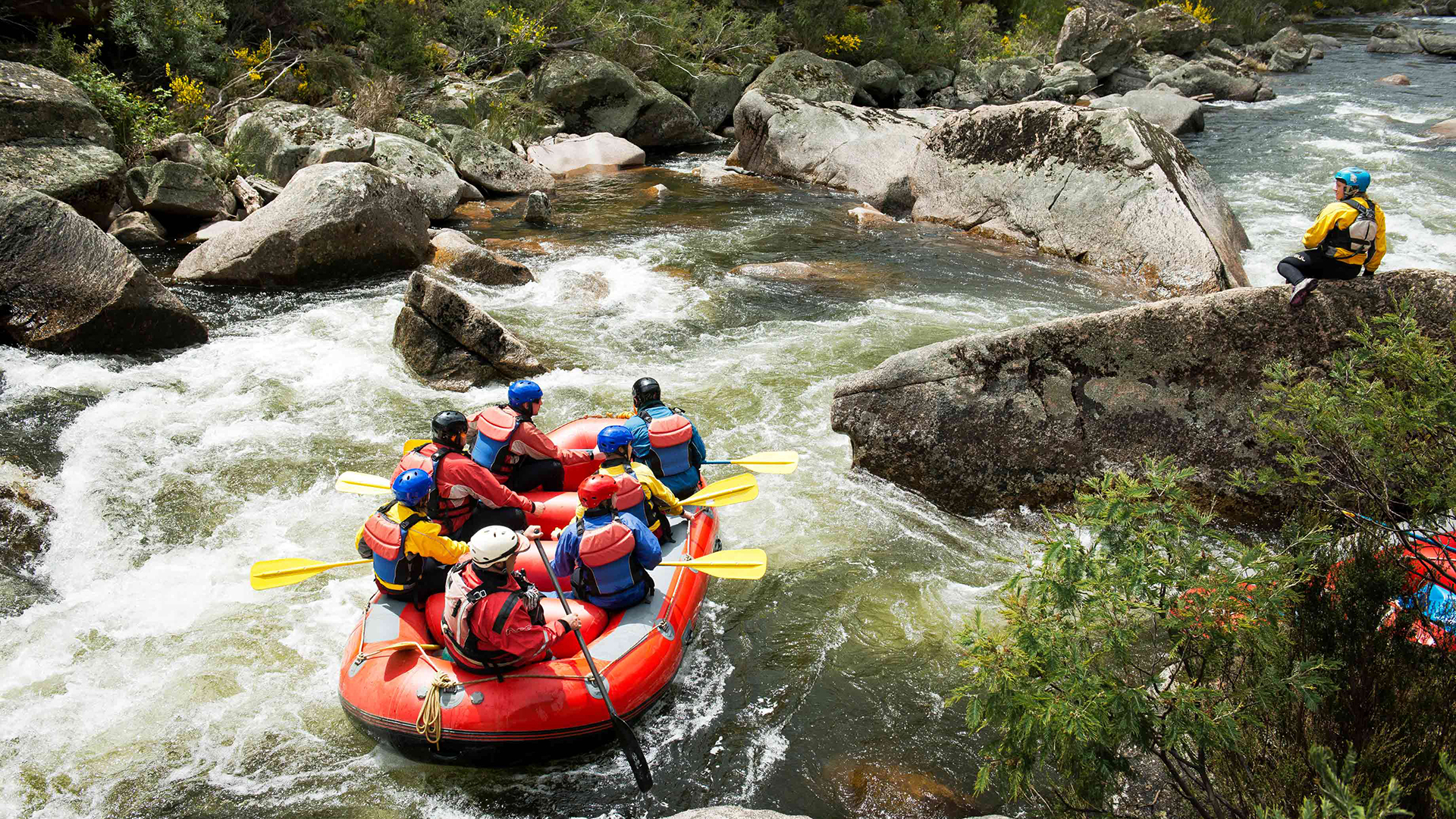
Riding the rapids through the gorge carved by the Mitta Mitta River.
The beauty is without question – the floodplain dotted with billabongs, and the course of the river marked by a proliferation of English willow. Yet the willow is a scourge. It was introduced in the 1800s for aesthetic reasons and because its extensive root mass would help hold the riverbank together. But, long term, it’s proved disastrous and now the North East Catchment Management Authority (NECMA) is trying to eradicate willow at key points on the river.
We catch up with a NECMA team at the caravan park at Mitta Mitta township, where the river is joined by its last significant tributary, Snowy Creek. This confluence is another significant Ya-itma-thang campsite.
“[The willow] has created this legacy of encroachment into the streams, collapsing and turning into mid-stream islands that create erosion issues,” says Mick Broughton, project officer for NECMA’s Channel Capacity Program. “As their root system develops, they shallow out the stream bed, so what would be once classed as a mild flood within the channel is breaking out. It impacts landholders and public infrastructure.
“The program is about ensuring capacity of the river so that flows released from Dartmouth get to Lake Hume in the same quantity and aren’t impacted by narrowing of the channel or any excessive water off-takes”.
Another impact is leaf drop in autumn/winter. “The willow dumps everything in one hit, and as that leaf litter breaks down, it takes oxygen away from the water”, Mick says. “That unbalances the macro-invertebrate ecosystem…and that impacts on it being a good source for fish and platypus. They move away from those really heavily infested areas”. Once the willow has been removed from key sites, the next step is to maintain the integrity of the river through fencing and revegetation.
NECMA is also improving the fish habitat on the lower Mitta Mitta after a 2015 census showed it to be severely depleted, the result of the irregular flow regime from the dam. Placing timber logs in the river at more than 20 sites has maximised survival rates and provided spawning opportunities for native species, particularly Murray cod. A 2017 audit showed that trout, redfin and freshwater crayfish were also there. “I can’t give solid data on what or why”, Mick says, “but it certainly shows that ‘if you build it, they will come’”.
This progress has come none too soon. A Sustainable Rivers Audit in 2012 reported the Mitta Mitta ecosystem was in poor health. The fish community received the lowest score of all the basin’s audited valleys: most expected native species were absent and alien species dominated, particularly the brown trout, which is found all along the river from Cobungra to Lake Hume.
The audit had better news, however, for the macro-invertebrate community, showing high diversity particularly in the upland zone. Riverine vegetation was in moderate condition overall, rating from extremely poor in the slopes zone to good in the upland and montane zones. The Mitta Mitta system’s hydrology was also rated as good, although there were significant changes in the flow seasonality.
This macro view, however, is not the concern of the willow team at the caravan park using chainsaws and a bulldozer, although one worker, Shannon Hanley, agrees he probably has a job for life. He asks about our interest in the Mitta Mitta, and I say it’s part of a travel series on wild rivers around Australia.
He smiles. “You couldn’t have chosen a better river”.
How to Explore the Victorian High Country
Wild rivers cascade down dramatic, rolling mountains and tree-lined valleys in the immense outdoor playground of Victoria’s spectacular High Country, located in the state’s north-east.
A haven for fishing, bushwalking, camping and skiing, it has the feel of a remote wilderness and never feels crowded, even in summer, despite being less than three hours by road to Melbourne. The historic villages and towns that dot the landscape boast fine-dining restaurants with local wines and craft beers to take the edge off a day’s hiking or cycling. There are also some great tours in surrounding areas.
THE ESSENTIALS
WHERE: The High Country starts at about 2.5 hours out of Melbourne.
WHEN: All year round. Each season is special, with winter heralding some of the country’s best skiing.
HOW: Driving is the best way, and there are a number of tourist drive routes to explore once you’ve arrived.
DON’T MISS: A visit to at least one (and preferably more) of the region’s historic cattlemen’s huts is a must-do.