
Kakadu’s Seasonal Rhythms
Words: Joanna Hartmann | Photography: David Hancock.
Wind gushes through the cabin’s open doorways as sheets of fine, silver rain slap against the windscreen. A wall of thick cloud is building over the Arnhem Land plateau and rolling quickly towards us. “This will certainly give you an appreciation of the weather,” Clancy says, as we rapidly drop and bounce into the storm. The tonne of metal that makes up the R44 seems insignificant compared with the force of the wind jerking us from side to side. The edge of the escarpment rushes past, and just up ahead a puff of smoke-like mist rises from its rugged sandstone stacks. At once, in full wet-season magnificence, Twin Falls comes into view; its water thunders over the escarpment and surges into Jim Jim Creek below.
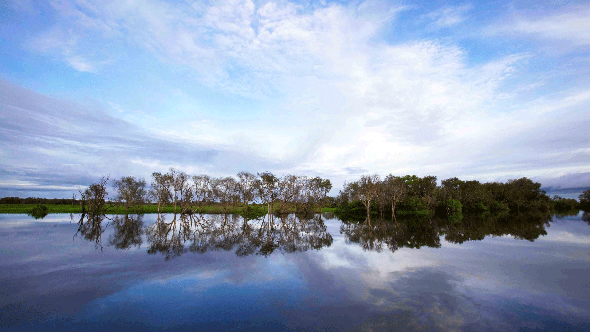
Every wet season, three months of heavy monsoonal rain drains off the plateau and inundates Kakadu’s floodplains. The plateau’s edge is a dramatic escarpment that forms much of the eastern border of the 19,804sq.km national park. Once lapped by ancient seas, it has stood sentry over Kakadu’s lowlands for about 140 million years, and now bears witness to the region’s annual transformation from lush freshwater wetlands, covered in the iridescent blue-green hue of spear grass in the Wet, to massive expanses of arid savannah woodland in the Dry. Studded with termite mounds and punctuated by shrinking billabongs, this dry-season landscape takes on the colours of scorched ochre.

Kakadu. Image Credit: Courtesy Emilie Stevski/Tourism NT
Roughly one-third the size of Tasmania, Kakadu stretches across the Top End, from the Wildman River east towards the Arnhem Land plateau and south from the Van Diemen Gulf towards Pine Creek and adjoining Nitmiluk National Park. “Its immensity is something that’s really hard to conceptualise,” Sarah Kerin, the regional director of Savannah/Central Park operations tells me as we sit at Bowali, the park’s main visitor centre. “There’s a really distinct rhythm up here, a seasonal rhythm between the dry season and the wet season,” she says, as a heavy shower drums on Bowali’s corrugated-iron roof. “During the Wet the landscape is green and beautiful. You have the recharge of all the aquifers: the streams, the billabongs, the floodplains. You’ve got the geese that are out feeding and growing fat and thinking about nesting; it’s just exquisite.”
Kakadu was established in three stages between 1979 and 1991, and was World Heritage-listed in 1992 for its natural and cultural values. The floodplains, tea-tree scrub and mangrove-fringed mudflats that make up the lowlands cover a vast eroded plain, and were inundated when sea levels rose higher than they are today. They comprise Kakadu’s extensive Ramsar-listed wetlands, which officially span the entire park.
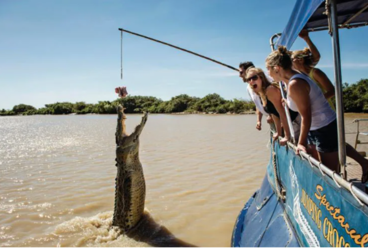
The wetlands attract up to 3 million waterbirds each year, including egrets, brolga, jabiru and comb-crested jacana. During the Dry (May–October), Kakadu’s billabongs act like sponges, drawing in diverse wildlife, such as whistling ducks and magpie geese, which flock in their thousands.
The park is home to about a third of Australia’s 800-plus bird species and a quarter of the continent’s land mammals. It is the most species-rich region for fresh-water fish in Australia and still contains nearly all the plants and animals that were present before European settlement, including many endemic species such as the black wallaroo, Arnhem rock-rat, Kakadu dunnart, white-throated grass-wren, chestnut-quilled rock pigeon, giant cave gecko and Leichhardt’s grasshopper.
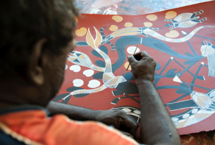
It’s been recognised as a living cultural landscape. The earliest known human occupation sites on the continent are situated within the park’s boundaries, and Kakadu’s Traditional Owners, the Bininj/Mungguy, continue to care for the land as their ancestors did more than 50,000 years ago.
There are up to 15,000 rock-art sites cradled within Kakadu’s stone country, 5000 of which have been documented. They make up the greatest known concentration of rock art in the world, with some paintings dating back more than 20,000 years.
Despite the natural and cultural riches, a century and a half of European occupation has led to the introduction of invasive weeds and animals, and resulted in changed management practices, such as land clearing and destructive fire regimes. On top of this, the area’s more recent history has seen Australia’s largest uranium mine, a service town and buffalo farm all right in the middle of the park.
Image credits: James Fisher/Tourism NT
Today, more than half of Kakadu belongs to the Bininj/Mungguy people, and most of the remaining land is under claim. Traditional Owners lease it to the federal government’s director of parks, so it can be run as a national park under a joint management scheme.
“Our culture is alive and thriving,” Traditional Owner and community leader Jessie Alderson tells me as we shelter from a downpour on the Jim Jim ranger station’s verandah in central Kakadu. Close to half of the park’s permanent staff are Indigenous. “We still keep our practices going, you know, hunting and camping and teaching our young people,” she says.
“Some of the Traditional Owners are the best naturalists we’ve got,” says Steve Winderlich, the park’s natural and cultural programs manager. “They rely on a lot of the native species for food, so they know what’s happening with weeds, for example, because weeds choke habitat for cultural and food species.”
Steve explains how Kakadu’s land-management plans encompass a strong cultural focus. For example, the fire plan, which involves regular controlled burns to reduce fuel loads when spear grass dries out at the end of the Wet, has both an ecological and a cultural component. “The cultural component involves looking at how traditional burning was carried out, but there’s also the impact on cultural sites to consider,” he says. “Fire too close to rock-art sites can exfoliate the rock, and then the art’s gone.”
“Come wet season, like now, the ground’s nice and wet and the weeds start to come up so we’ve got to go out and catch them before they seed,” says Bolmo Deidjrungi man and ranger Fred Hunter.
Fred was born at Madjinbardi (Mudjinberri), a community in north-eastern Kakadu. He completed a parks apprenticeship 26 years ago, and has been a ranger ever since. For more than a decade, he’s been a member of a four-strong team that targets one of Kakadu’s main invasive weeds: mimosa, a woody shrub introduced from Central America. “In the park there are about 300 mimosa plots,” he says. “We have to check each of them at least five times a year. A seed can stay in the ground for 20 years and there’s a risk a pig will come along and dig it up, and you’ll get another plant growing.”
I meet Fred and his team at a point on the road between Jabiru and Gunbalanya (Oenpelli) where the bitumen is covered in water, and Fred launches the Swamp Master.
The roar of the airboat’s huge fan thunders across the watery landscape as we plane along the submerged highway. We’re heading for Marnanj, the Magela Creek floodplain, where Fred and his team will check mimosa plots on the Djarr Djarr billabong. “During the wet season we use airboats and helicopters to check plots,” Fred says. “In the dry season we go out on quad bikes. We go everywhere. Wherever mimosa grows, that’s where we go.”
As we jet across the billabong, a large white cloud mass starts spitting rain. The escarpment makes for a dramatic backdrop, and from this vantage point, as we swerve around the tips of submerged termite mounds, the power and sheer scale of Kakadu’s dramatic Wet-Dry cycle really hits home. In a matter of months, this expanse will be a stretch of dry savannah woodland. I’m glad I’ve seen Kakadu’s ever-changing landscape at its wettest.
I recall my conversation with Sarah Kerin. “I would definitely recommend people come twice,” she’d said. “There’s nothing more beautiful than looking up over the escarpment at a canopy of stars on a dry-season night. Or simply going out and walking around Anbangbang Billabong on an early dry-season morning when you have the mist and you can smell the swamp and the lilies. It’s just beautiful. During the wet season the park is entirely different. It’s characterised by rejuvenation and a refreshment of the landscape.”
How to Explore Kakadu
One of the few World Heritage areas to be recognised for both its spectacular natural features and cultural importance, Kakadu National Park attracts visitors to its dramatic ridges, billabongs, towering waterfalls and dense rainforest, all ripe for bushwalking, swimming, wildlife encounters and striking 20,000-year-old Indigenous rock art.
The Traditional Owners recognise six seasons. As the waters rise during the wetter months, so does the diversity of wildlife, while the cooler, drier times of the year herald an influx of tourists – though it’s never crowded.